Application Description
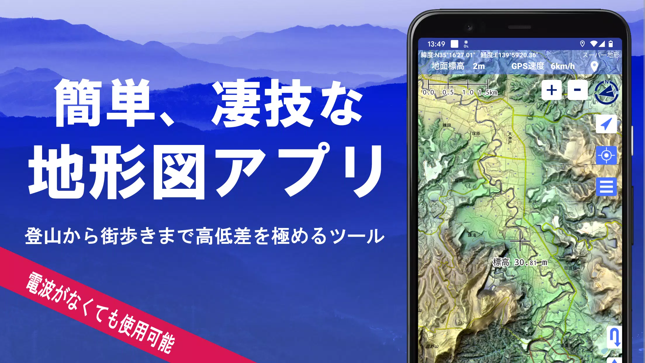
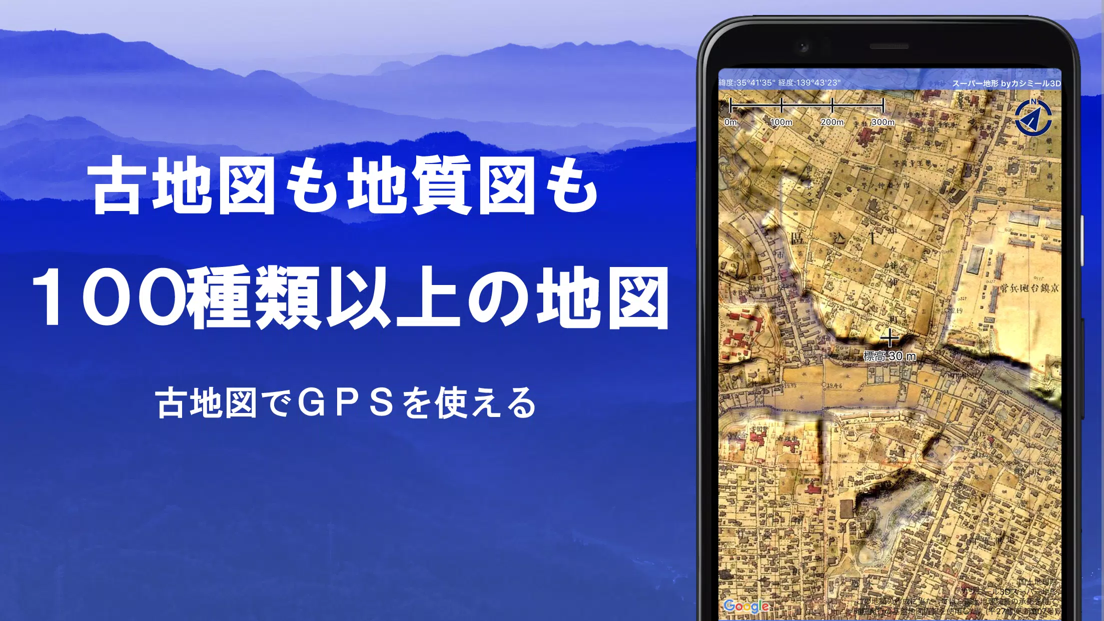
Discover the power of the Super Terrain app, which offers over 100 types of maps, including those from the Geographical Survey Institute, perfect for everything from mountain climbing to exploring urban environments. The app received the prestigious 2018 Japan Cartographic Society Award for Best Work, showcasing its excellence in mapping technology.
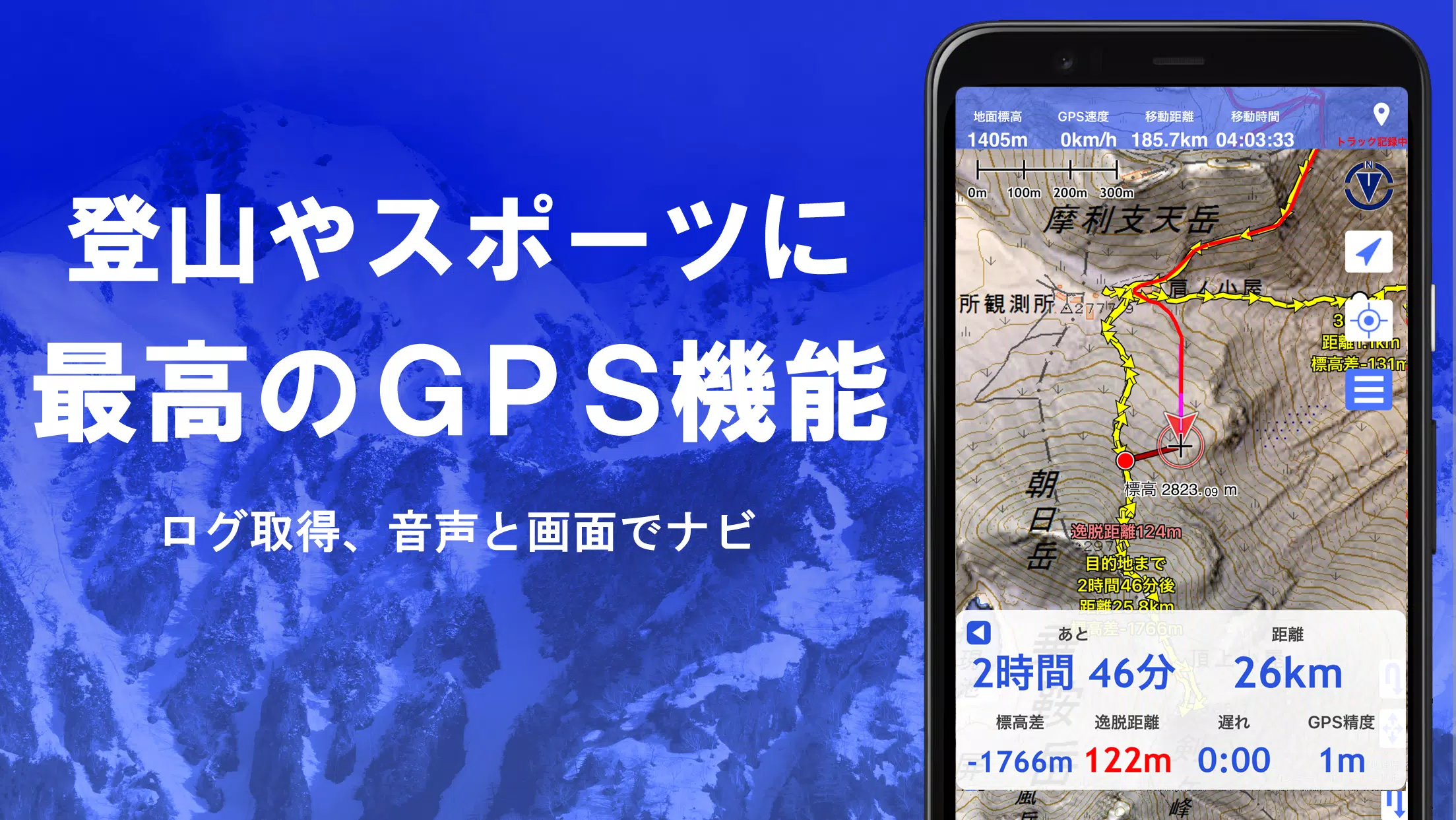
Utilize the "super terrain data" feature, which highlights terrain through unique technology, along with maps from the Geospatial Information Authority of Japan, such as topographic, geological, historical, and prewar maps. Record your tracks using the GPS function, with GPX log input/output and editing capabilities to enhance your navigation experience. The app supports various outdoor activities with features like GPS navigation with audio cues, data recording, and editing.
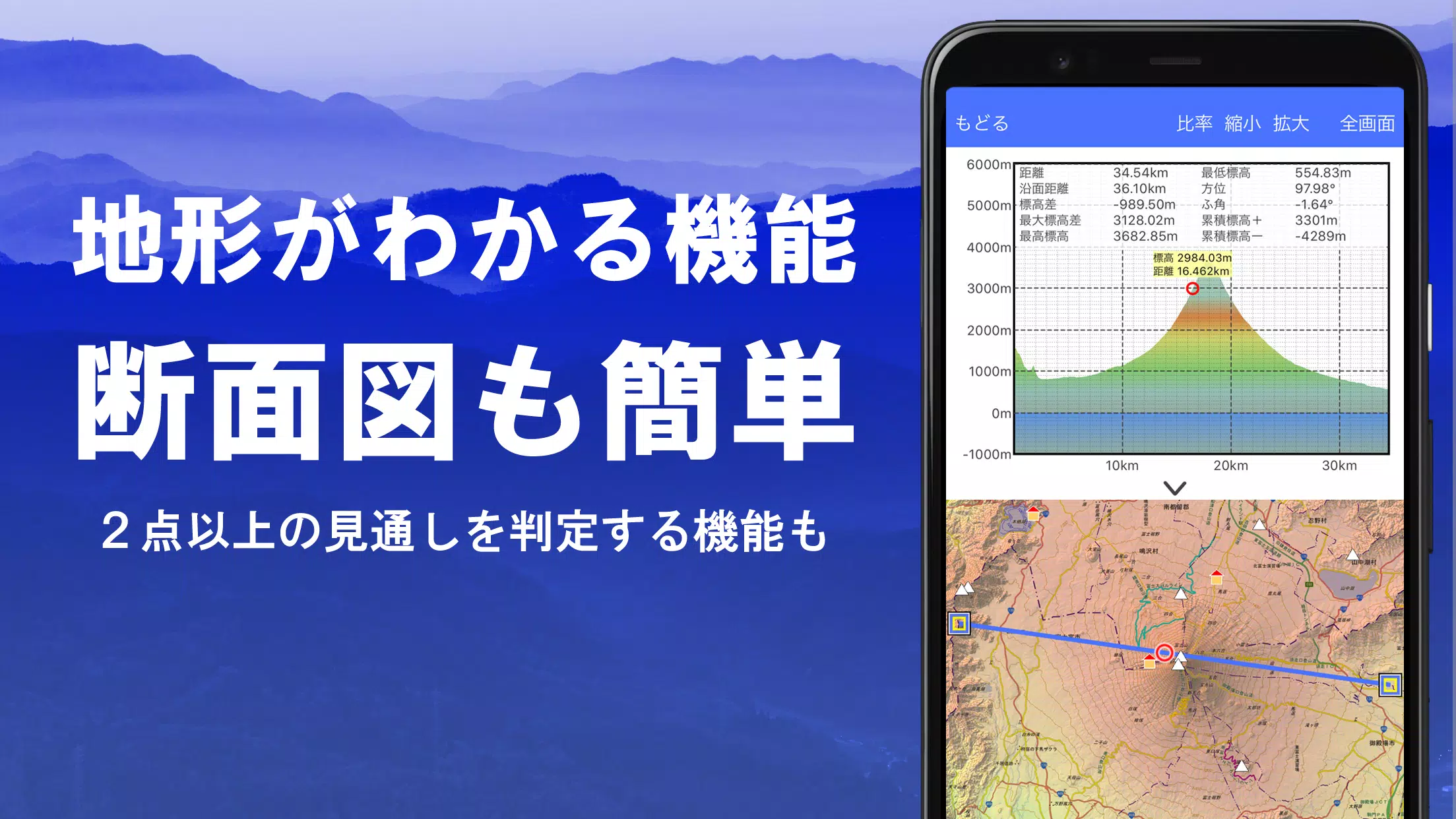
The visibility determination function is excellent for creating cross-sectional diagrams, aiding in observation and radio signal analysis. You can even view buildings, and the 360° panoramic view function helps you identify mountains by name. Display celestial bodies like the sun and moon, along with GPS points, and enjoy offline map usage with bulk download and cache functions for uninterrupted exploration.
Associate photos with specific locations, view contour lines generated from elevation data, and display MGRS grids for precise location tracking. The app supports reading, displaying, and editing GIS data from GeoJSON files, drawing shapes, and works seamlessly overseas. You can print maps and export them as PDFs, and the app supports a dark theme for comfortable viewing.
A Wealth of Maps at Your Fingertips
With over 100 map types available, including our proprietary super topographic data and maps from the Geospatial Information Authority of Japan, you have a vast array of tools for your adventures. Note that aerial photographs may vary by age, with "latest" and "around 1974" offering broader coverage. Enjoy a 5-day free trial of maps using super terrain data after installing the app.
Cross-Section and Outlook Creation
Effortlessly draw cross-sections through any point on the map, equipped with a visibility judgment function that accounts for Earth's curvature and atmospheric differences. This is invaluable for route planning, assessing wireless visibility, and understanding terrain. With PLATEAU building data, you can even create cross-sections that include buildings.
Elevation Palette Function
Enhance your map visuals using the elevation palette function, which lets you change the map background color in 1cm increments, allowing you to customize your maps to your preferred color gradation.
Panoramic View
Experience panoramic observation maps that reveal mountain names from any map location, integrating with your smartphone's compass for a 360-degree view. This feature is perfect for identifying mountains and can display the sun and moon, including moon phases, aiding in spotting phenomena like Diamond Fuji and Pearl Fuji. You can also view GPS points and explore panoramic views of international mountains.
GPS Functionality
Leverage your smartphone's GPS to obtain location information and record tracks with high-precision positioning ideal for serious outdoor and mountain climbing activities. Visualize your recorded tracks with detailed parameters like elevation gain, speed, time, and elapsed time. The point alarm function provides voice and alarm notifications as you near designated points, and you can display photos linked to these locations. Additionally, you can send the map center position to NaviCon for further navigation.
GPS Track Summary Playback
Play back your recorded tracks in full, with the app automatically displaying photos taken at corresponding times. An icon marks the photo location, which you can view by tapping.
GPS Navigation Function
Navigate along preset tracks using the Track Navi function, with voice or alarm notifications if you stray from the path, ensuring you won't get lost while climbing. The app also supports route navigation for urban walks and point navigation for targeting specific locations.
GPS Data Editing Function
Manage your GPS-related points, routes, and tracks in organized folders, displayed in an easy-to-read tree format. Create tracks directly on the map, and import or export data in GPX format from mountain climbing websites.
Map Usage Outside the Service Area (Offline)
Continue using maps in areas without signal, like during mountain climbing, with the bulk download function that lets you download all scale maps for a specified area. A cache function further ensures you have maps at your fingertips, even offline.
Map History Function
The app remembers your previous locations, allowing you to easily return to them.
Custom Map Compatibility
Import and use custom maps created with Kashmir 3D's map cutter, including your own or scanned maps. When using the map cutter, divide images into roughly 256 x 256 segments and send the kmz file to Super Terrain via email or Cloud Drive.
GeoJSON Compatibility
Display and edit points, linestrings, and polygons from GeoJSON format files, with the ability to draw new shapes.
Print/PDF Output
Print any map area at a specified scale or create a PDF for later use.
Integration with Other Apps
Input and output GPS data in GPX, KML, and GDB formats, enabling data exchange with other apps and the Kashmir 3D software on your PC, and utilize trajectory data from mountain climbing sites.
Backup Function
Back up all app data (excluding cached maps) and remove it from your smartphone. Restore your data even if you delete the app or if your smartphone malfunctions. Automatic backups to Google Drive ensure your data stays current.
Billing Function
Certain features like maps using super terrain data, GPS track functions, and cross-sectional views require in-app purchases. After payment, the number of place name search results increases. The annual fee is 780 yen, with a 5-day free trial upon first installation. To purchase, navigate to [Settings] - [Purchase to remove functional restrictions] within the app. Manage or cancel automatic updates through Google Play under "Regular Purchase" - "Super Terrain". Prices may change with future enhancements, so consider purchasing early for the best value.
Terms of Use
The copyright holder and developer are not responsible for the outcomes of using this application. When first using GPS, allow the use of location services. Note that continuous GPS use can drain your battery, so carry a spare if your device is used for emergency communication. A detailed explanation of the navigation function is available in PDF format at this link. Be aware that on some smartphones, track recording may be interrupted due to power-saving features, which the app cannot mitigate. If you turn off the screen while using Super Terrain, recording may persist temporarily, but this is not a permanent solution.
Screenshot
Reviews
Apps like スーパー地形 - GPS対応地形図アプリ